We were once invited by a major construction company in Nigeria to discuss some solutions they were looking to deploy. They knew it existed, but had never used such on any of their projects. We then had the opportunity to help this company understand the possibilities around aerial intelligence in the construction industry and the options available in deploying aerial data gathering using drones. I aim to use this particular problem statement from the company as a basis to discuss the subject matter.
Often, you find yourself working for clients who do not understand their needs, talk less of what technology solution to engage. People come across exciting new tools and want to feel cool using these to stand out from their competition. However, using cool tools does not guarantee that you will deliver quality goods or services. Technology is not an end in itself. It is merely an enabler and a process tool to arrive at desired outcomes. First, businesses have to determine what they want to achieve. Second, they need to appraise their processes to see where the technology intervention needs to happen before they seek out the technology options available to them.
The managers in this construction firm were quite clear and had a firm grasp of the challenges they wanted to solve. Their clarity made the conversation very valuable and the solutions attractive to them. Their challenge was how to capture the As-Built structure, render it in a 3D CAD model, then match this with the original building design in an application like Revit to determine where and what kind of variations exists in an ongoing construction. Sounds complicated? Not exactly. Here is a simple explanation.
When a building is to be developed, the design concept is created first by the architect, and sometimes a miniature model of the design is also crafted. These designs are usually highly-detailed drawings to guide the building engineers as they build. However, when the construction is ongoing, deviations happen due to errors or deliberate changes made. These deviations can significantly affect the cost of the project, and contractors are better off knowing about these early enough to quickly correct anomalies and avoid an increase in the costs of a project. This is the problem we were invited to help resolve for this company.
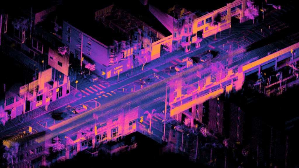
A drone mounted with a LiDAR camera can quickly scan the externals of a large structure in a matter of minutes. The result will be a set of data points in space called a point cloud.
While builders can easily handle such errors in smaller structures, it can be a nightmare for massive structures when unintended deviations happen. Imagine putting up a ten-story building and you then discover design errors when you get to the seventh floor. Obviously, time and money will be sunk in trying to correct this, and this will affect delivery time, which may eventually cost the business relationship with the client. I know of a university building where the engineers had to stop construction on the fourth floor due to a mistake in the foundation that prevented the builders from raising it to the predesigned seventh floor. These kinds of issues arise all the time in the construction industry, and solving this will be of tremendous value in time and resources for many firms.
The problem was clearly defined, and we immediately saw where our solutions could help mitigate their concerns. Because of the high levels of measurement accuracy that the industry needs, we recommended that a drone mounted with a LiDAR scanner be used to capture high-density point clouds of the external structure, while a similar scanner is used inside the building. A LiDAR (Light Detection and Ranging) scanner is a device that uses laser pulses to measure distance and then represent each measured distance as a point in its data output. Based on the type, LiDARs can generate thousands of pulses per second. This process is known as the scanning frequency. Some modern LiDAR equipment can release over 150,000 pulses per second. The higher the scanning frequency, the denser the point cloud gathers, which improves the quality of the measurement of the scanned structure or environment.
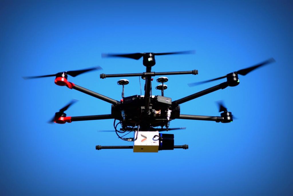
A drone mounted with a LiDAR camera can quickly scan the externals of a large structure in a matter of minutes. The result will be a set of data points in space called a point cloud. The higher the specification of a LiDAR scanner, the higher the data points per defined area one gets. Larger data points, therefore, lead to more accurate measurements. In surveying and construction, usually, the goal is to achieve a 2cm and below distance between each data point. It will ensure that when the data points are then converted into a building information model (B.I.M) the geometry will best capture the exact measurements of the As-Built structure.
The ability to do this makes a world of difference to building engineers. The longer-term value of this approach is that such data capture will happen continuously, say every workweek, and building variations can be easily spotted and resolved. The entire process from capturing the data to analyzing it takes a matter of hours, as opposed to a more manual process that can take very many days to accomplish and is still prone to severe measurement errors. One drone, on a single battery charge, can help scan the external structure of a building complex. For instance, in the case of a 35,000 capacity stadium renovation project, it took a drone mounted with a Riegl LiDAR camera about 80 mins to capture the entire complex with a scanning frequency of 200 kHz( 200,000 laser pulses per second).
While aerial LiDAR technology has been around since the 1960s, it was mounted mostly on airplanes and helicopters for wide-area surveying and mapping. With the advancements in Small Unmanned Aerial Systems (SUAS) or drones, it is becoming even more effective to deploy such remote sensing tools on these remotely piloted small aircraft, which can fly at lower heights and in more risky terrains. The quality of data gathered and the accessibility is far more beneficial today for several uses cases around the world. The construction industry is indeed a big beneficiary of these developments. Drones and their relevant payloads are readily deployed for construction around the world today. The construction industry in Nigeria is also ripe for exploring these new tools to increase productivity and drives costs down.
Let me conclude by summarizing the key areas in the construction industry where drones are providing added value. Drones can:
- Help produce detailed Aerial 2D/3D survey maps of project sites for Building Information Modeling (BIM). They are critical for thorough site assessment in matters such as topography, existing infrastructure, present hazards, etc.
- Produce detailed Orthomosaic images for continuous site activity to aid in decision making for materials supplies and subcontractor monitoring.
- Create highly accurate Digital Surface Models, Digital Terrain Models, Slope Models, and High-Density Point Clouds for detailed visualization and measurement of project sites. It is also critical for Environmental Impact Assessments.
- Conduct aerial construction inspection for structural integrity using Heat Vision Cameras. It is a modern, faster, and more efficient way of assessing infrastructure.
- Perform aerial photography and videography of the project site for continuous monitoring of construction work from preconstruction through the construction phase and post-construction analysis.